(Thanks to Santana for the backup track.)
Wednesday, October 30, 2013
El Cabito Restaurant, Las Galeras, Dominican Republic
Here' my video featuring the blowhole at this popular restaurant where we dined with family who came to visit us while we were living in the Dominican Republic last winter.
(Thanks to Santana for the backup track.)
(Thanks to Santana for the backup track.)
Thursday, October 3, 2013
Decommissioning the RV
We just camped in our old travel trailer for the last time. We have put money down on a newer rig but haven't taken delivery of it yet, so we made a spontaneous decision to take advantage of the mild weather of early autumn and take the old camper out for one last outing.
It's only an hour's drive to our favorite campground on the beach at the tip of the Thumb at Port Crescent State Park, and we were able to get the same site we had last year within a few yards of the beach.
Port Crescent's golden sands are perfect for beach walking and the water was still relatively warm. The weather was unusually mild for this time of year and we were able to linger out by the campfire well into the evening.
We have been really excited about the newer fifth wheel and are anxious to bring it home and set it up with the necessary provisions for our once-in-a-lifetime journeys to California and Alaska and the other far corners of the country, but on this excursion we did a lot of reminiscing. We have owned the old travel trailer for ten years and have built a lot of memories.
This is one of the trailers that my construction crew stayed in while we were building new log homes all over the state a few years ago. We worked year 'round, so this was our home away from home even through several winters.
But we have to have something bigger for our next adventures, because Kaye and I will be living in it for months at a time as we tour the U.S. from coast to coast. The new RV has a slide-out that expands the living space and should be a great help in preventing cabin fever.
The sun has set on our adventures with the old Jayco. We are looking forward to a new dawn with the newer Coachmen. Watch for upcoming posts with the new rig!
It's only an hour's drive to our favorite campground on the beach at the tip of the Thumb at Port Crescent State Park, and we were able to get the same site we had last year within a few yards of the beach.
 |
| We can enjoy a panorama of Lake Huron from our favorite campsite at Port Crescent. |
 |
| Our favorite beach walk takes us west a half mile to where the Pinnebog River empties into Lake Huron. |
 |
| Anybody looking for a vintage travel trailer? It's a 1978 Jayco, and it's too small to live in for more than a few days. |
But we have to have something bigger for our next adventures, because Kaye and I will be living in it for months at a time as we tour the U.S. from coast to coast. The new RV has a slide-out that expands the living space and should be a great help in preventing cabin fever.
 |
| So the sun has set on another Lake Huron shoreline adventure. |
Sunday, September 29, 2013
Michigan's Sandy Shorelines
Michigan is defined by it's natural boundaries - the Great Lakes. The lower peninsula is shaped like a mitten which is bordered by sandy beaches on the west-facing shorelines along Lake Michigan and mostly stony beaches facing east along Lake Huron (see my earlier post describing some of Michigan's Rocky Shorelines).
Probably the most impressive stretch of sandy shoreline is near Traverse City at the Sleeping Bear Dunes National Lakeshore which includes several miles of perched sand dunes along the Leelenau Peninsula and the large offshore archipelago, North and South Manitou Islands. These large sloping sand dunes tower 450 feet above the beach and Lake Michigan. The Manitou Islands are premiere backpacking destinations and offer real seclusion for the wanderer seeking remote solitude.
 |
| The view of Lake Michigan from atop the bluff at Sleeping Bear Dunes National Lakeshore. |
South Manitou Island has designated campgrounds, fresh water supplies, lighthouse tours and shipwrecks. On North Manitou hikers are allowed to camp anywhere away from a body of water or a historical building (there are remnants of ghost towns on both islands) and must filter or boil water for drinking and cooking. Friends of mine who just camped on North Manitou two weeks ago reported that they didn't see another human being for several days while hiking and camping on the large island.
 |
| Hikers descend the dunes for an evening swim in Lake Michigan - before the grueling return climb. |
The west Michigan shore is basically a 200-mile-long stretch of sandy beach that is interrupted every few miles with a lighthouse and harbor town. Not only the area inhabitants but also thousands of tourists have tapped in to the beauty of this region with swimming, boating, kayaking, fishing, diving, four-wheeling, kite boarding, skinny dipping... and a whole lot more.
 |
| Young hikers on South Manitou Island. |
Many of the beaches that line Michigan's west coast are managed by city and state park services, and private land owners keep an eye on their waterfronts, but there are vast stretches of sand that don't seem to be regulated by anybody - there's simply nobody around. Ah, what seclusion, what freedom, what natural beauty, stretching for miles and miles!
On the eastern side, there are also golden sands that border the sunset side of Michigan's "Thumb" from Caseville up to Sleeper State Park and Port Crescent State Park near Port Austin at the tip of the Thumb where the beaches end and the stony bottoms of the eastern shores take over.
 |
| South Manitou Island snorkelers leap from the wreck of the Morazan, a freighter grounded during a blizzard in 1960. (This activity is not endorsed by the Park Service.) |
There are few places where it is legal to drive your Jeep on the beach, but at Silver Lake Dunes you are welcome to drive around on the sand dunes in your dune buggy or other four-wheel-drive vehicle, and there are many campgrounds nearby.
Visitors are often surprised at the shorelines of Michigan and the vast beauty - and recreational opportunity - that they present. One could spend a lifetime enjoying all of this, but there's something to keep in mind before scheduling a visit here: Michigan is crossed by the 45th parallel, the latitudinal half-way point between the equator and the north pole, and this means that winters are harsh here. And the beaches are deserted while the local inhabitants hibernate next to the fireplaces in their cabins. The lakeshore is not a safe place to be when the snow is blowing, the wind is howling, and the ice is piling up on the beach in huge mounds. That's why many Michiganders head south for the winter.
But in the warmer months the Michigan shorelines - whether sandy or stony - are some of the most inviting spots in the midwest! My personal favorite time is September after Labor Day when the kids have gone back to school and the campgrounds are empty but the water is still warm enough for wading, snorkeling or diving (I keep a wetsuit with my snorkeling gear in case the water temp isn't quite warm enough for me) . And the cool evening temps make the campfire even more appealing. Ah, peace and quiet!
 |
| Each September, Kaye and I camp within a few yards of the beach at Port Crescent State Park |
Saturday, July 27, 2013
Rural Michigan Summer
The seasons are no more obvious in the northern U.S. than out in the country. In the city it is hard to see the changes that take place so gracefully and continuously outside of town. In farm country there are more than four seasons as each one can be further divided into a myriad of micro-seasons.
In the summer, for example, over a few weeks the wheat changes from bright green and grassy-looking in May and June to golden and grainy at harvest time in July. The corn changes from knee-high by the fourth of July to nine feet high or more by August first. The entire landscape goes through a continuum of overhauls right before our eyes.
Kaye and I have not been traveling as much this summer because we enjoy the beauty of our secluded home in the log cabin here in central Michigan. And we've been staying home intentionally to save money for our next big ventures to California and Alaska.
So we are enjoying the sojourn of the seasons all around us here in the middle of the farm community where Kaye grew up as the daughter of a dairy farmer.
I am a visually stimulated sort of guy, and I often see things that ignite my imagination on this journey through the seasons. Today I pictured some nonsense in the field of huge round straw bales that we pass on our way to the highway and back. Staging a bit of silly-ness is a lot of fun for me and even more so when my wife is willing to go along with it. Here are the results of our latest craziness, some just-for-fun photos of our peaceful countryside surroundings. The straw bales were rolled a day of two after the wheat was harvested. They'll probably be around for a while, so who knows what nonsense will follow over the next few weeks.


Thanks to Kaye for conspiring in the nonsense!
Hmm, I wonder what we can do with 10-foot high corn fields next?
Wednesday, July 3, 2013
Michigan's Rocky Shorelines
Michigan has more shoreline than either Florida or California. And it has more inland lakes (about 11,000) than Minnesota, which is said to be "the Land of 10,000 Lakes". And Michiganders own more boats than the constituents of any other state. I guess maybe it is the "Texas" of freshwater lakes.
Much of Michigan's shoreline is rugged and rocky, especially surrounding the upper peninsula where there are forest-covered cliffs and crags and boulders along many miles of the shore. The lower peninsula is sandy along the entire west side bordering Lake Michigan, but the eastern shore, bordering Lake Huron, is a mix of stoney bars and sandy beaches. You could generalize that if the beach faces west, it is sandy, and if it faces east, it is stoney.
The Lower Peninsula
The only real stretch of rugged shoreline in the lower peninsula is at the tip of the Thumb where there is an outcropping of shale that stretches for several miles. The most prominent landmarks are Hat Rock, Table Rock, and Turnip Rock. These are accessible mostly from the water, as there is private property bordering much of this shore.
As the crow flies, Turnip Rock is a couple of miles east of the village of Port Austin, but the trip by water is much farther because there is a stone bar that extends almost 2 miles from shore, so the boater must add several miles of paddling to get around this formation, unless he is willing to portage across the stones to shorten the trip (wear heavy-soled sandals or sturdy water shoes). On a nice day it takes about an hour-and-a-half, unless the wind is against you. This upside-down "V" route takes you within a half mile of the Port Austin Reef lighthouse at the northernmost point.
During my last visit there it seemed odd to me to be able to get out of my kayak and walk around on the flat shale bottom in only 2 or 3 feet of water... when I was 2 miles from the nearest shore!
It's a good idea to call ahead for availability of rental equipment at Port Austin Kayak Rentals. After a hard day of paddling on the lake, I found Joe's Pizzeria in Port Austin to be a welcome landing for delicious pizza and pasta and a whole lot more.
The Upper Peninsula
Michigan's most famous shoreline in the upper peninsula is the Pictured Rocks National Lakeshore which is managed by the US National Park Service. This impressive Lake Superior shoreline is dominated by sheer cliffs that reach over 200 feet high and are punctuated by arches, overhangs and caves. There are hiking trails that follow the tops of these cliffs making it a popular backpacking destination.
A few campgrounds are scattered throughout the park, and it's important to make reservations early if you hope to get a good campsite. This is back country camping, so there are few water pumps to be found. Most everyone dips water from the lake or stream and either boils it or filters it for drinking and cooking.
It is possible to see the Pictured Rocks from below by boarding a tour boat in the town of Munising a few miles to the west. Also, kayaking is becoming an ever more popular means of getting up close to the caves and arches that undercut the huge cliffs.
The Pictured Rocks are not the only picturesque shoreline along Lake Superior. Among the other famous locations is Isle Royale, a large and remote rocky island that is home to populations of both wolves and moose. Camping and hiking on Isle Royal is limited and requires working months ahead to reserve a spot on the ferry and a back country camping permit.
Lake Superior waters are always cold even in the late summer, so swimming is not usually on anybody's agenda. If you're kayaking, have a way to keep warm with a wetsuit or warm waterproof clothing.
After your hiking or kayaking adventure, don't forget to enjoy one of the famous north Michigan pasties at one of the local eateries like Muldoon's Restaurant in Munising which always gets good reviews for its authentic scandinavian cuisine.
Much of Michigan's shoreline is rugged and rocky, especially surrounding the upper peninsula where there are forest-covered cliffs and crags and boulders along many miles of the shore. The lower peninsula is sandy along the entire west side bordering Lake Michigan, but the eastern shore, bordering Lake Huron, is a mix of stoney bars and sandy beaches. You could generalize that if the beach faces west, it is sandy, and if it faces east, it is stoney.
The Lower Peninsula
The only real stretch of rugged shoreline in the lower peninsula is at the tip of the Thumb where there is an outcropping of shale that stretches for several miles. The most prominent landmarks are Hat Rock, Table Rock, and Turnip Rock. These are accessible mostly from the water, as there is private property bordering much of this shore.
 |
| Turnip Rock is best reached by canoe or kayak. |
 |
| Port Austin Reef Lighthouse is 2.5 miles from land. |
During my last visit there it seemed odd to me to be able to get out of my kayak and walk around on the flat shale bottom in only 2 or 3 feet of water... when I was 2 miles from the nearest shore!
It's a good idea to call ahead for availability of rental equipment at Port Austin Kayak Rentals. After a hard day of paddling on the lake, I found Joe's Pizzeria in Port Austin to be a welcome landing for delicious pizza and pasta and a whole lot more.
The Upper Peninsula
.jpg) |
| Michigan is rich in hiking destinations. |
Michigan's most famous shoreline in the upper peninsula is the Pictured Rocks National Lakeshore which is managed by the US National Park Service. This impressive Lake Superior shoreline is dominated by sheer cliffs that reach over 200 feet high and are punctuated by arches, overhangs and caves. There are hiking trails that follow the tops of these cliffs making it a popular backpacking destination.
 |
| Hiking trails are perched atop the cliffs and call for caution. |
It is possible to see the Pictured Rocks from below by boarding a tour boat in the town of Munising a few miles to the west. Also, kayaking is becoming an ever more popular means of getting up close to the caves and arches that undercut the huge cliffs.
.jpg) |
| Board the tour boat for an up-close look at the cliffs. |
.jpg) |
| The cliffs are riddled with caves and natural arches. |
 |
| Spray Falls drops 75 feet directly into Lake Superior. |
.jpg) |
| Hikers get their fill of the spectacular grandeur from the vantage points along the cliff top trails. |
Lake Superior waters are always cold even in the late summer, so swimming is not usually on anybody's agenda. If you're kayaking, have a way to keep warm with a wetsuit or warm waterproof clothing.
After your hiking or kayaking adventure, don't forget to enjoy one of the famous north Michigan pasties at one of the local eateries like Muldoon's Restaurant in Munising which always gets good reviews for its authentic scandinavian cuisine.
Thursday, May 23, 2013
Tulips and Old Technology
Last weekend my wife and I visited the west coast of Michigan for an early anniversary get-away, and we were privileged to see some famous sights and meet some interesting folks along the way.
 |
| The DeZwaan Windmill dominates the landscape at Windmill Island Park. |
Our first stop was the Windmill Park in Holland, Michigan, where the annual Tulip Festival had just ended the day before. The tulips were in top form, and the 400-year-old windmill was open for tours. Our guide was a Dutch American woman named Irene who was able to climb five flights of stairs to the fifth floor of the mill to give us a tour. This particular mill was a fully operational grist mill that grinds flour with the power of the wind, and there is some really old wooden technology inside. The gears are all made of wood, mostly ironwood, which is self-lubricating. It was bought from the Dutch and shipped to the US in 1964 sporting an array of bullet holes from being strafed by warplanes during World War II. It's the last windmill that was allowed to leave the Netherlands as they had just declared all their windmills as historic sites and were beginning to restore many them.
 |
| Irene gives a knowledgable and friendly tour of the old windmill. |
Next we had lunch with some friends at a Dutch restaurant called the DeBoer Bakery on the north side of town. The cuisine was authentic and delicious.
 |
| The 120-year-old Maplewood Hotel. |
We stayed at the Maplewood Hotel in Saugatuck for the next two nights, a nineteenth century edifice with much of the original woodwork intact. The floors creaked appropriately in a lot of places as we rambled through the convoluted corridors, and we imagined spooky tales of ancient ghosts roaming the halls at night.
Killwin's fudge shop in town was open and we took full advantage. Scooter's restaurant on the waterfront has some of the best pizza in town at a reasonable price.
Killwin's fudge shop in town was open and we took full advantage. Scooter's restaurant on the waterfront has some of the best pizza in town at a reasonable price.
We spent the second day of our trip near the Lake Michigan waterfront in the town of St. Joseph enjoying the parks and the wharf. This was my first opportunity to shoot the lighthouses there, and I was also happy to find the fishermen on the jetty hooking some catfish. I don't know if these guys knew I was coming or what, but their attire was perfect for the setting.

The Beachside Deli is an authentic Mediterranean restaurant downtown where the Greek gyro sandwiches are filled with a delectable mix of lamb and chicken and a specialty sauce. Mmm, terrific! It's on State Street near Broadway (not near the beach).
Kaye and I love the west side of Michigan, and return year after year to enjoy these very picturesque and welcoming people and places. I hope you get a chance to visit there too. There is a lot to see!
 |
| The lighthouses on the pier at St. Joseph/Benton Harbor guide the boats going and coming. |
Friday, April 19, 2013
The Dominican Journal
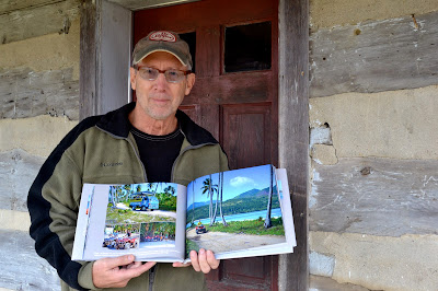
Well, the finished photo journal entitled, "The Young Men and the Sea" has arrived and I have proofed it; it looks fine. Fifty pages and 150 beautiful full-color photos depicting the people and culture of the eastern Samana Peninsula in the Dominican Republic. It's a hardcover collectible, a coffee table book with which I am well satisfied.
What I'm not happy with is the price. I researched several printing companies and discovered that nobody is able to deliver a quality photo journal at a reasonable price. Something about the heavy stock photo paper and all that vivid ink.
Anyway, I'm planning to order a quantity of them soon, and hoping to offer them on eBay and Amazon; I have business accounts at both vendors. Watch for them.

Wednesday, March 27, 2013
Oily Men in the Carnaval Parade - Help Please
Okay, I now have almost 300 photos edited from my winter in the Dominican Republic, and I'm about to start compiling the Photo Journal, the coffee table book that has been the object of this cultural project.
But I need your help. I feel that I have a working knowledge of the culture from living there for extended periods of time, but I've been stumped by a couple of things and would like to have my readers help me gain some background information on these things before I begin on the book. My goal is to have the book ready by the end of April.
 Here's one of my puzzles: While shooting the Carnaval Parade in the town of Samana, I photographed some guys who were covered with oil - at least I think it was oil. I touched the one guy and sure enough I ended up with a black smudge that I had to stop and clean off before handling my camera any further.
Besides the oily guys in this entourage, there were also a guy with his hands bound in cuffs, a "tyrant" behind them flogging them with a branch, and they were taking donations with a big can and a bag.
What is the back story on this tradition? What do these guys represent? If some of you would do some research and link me to the information, I'd be very thankful. If you come up with some good stuff, I'll mention you as a contributing researcher in the book.
Email me or make a comment here on the blog with the links. My email is: rasims@juno.com
Thank you!
Oh, here's the link to the photo gallery I'm working from for this book:
http://simsshotsphotography.zenfolio.com/p391431575

Okay, folks, I've had some people help me out with some great resources. It turns out that Los Africanos pictured here are representing the original African slaves who were brought to the Dominican Republic and became part of the Dominican heritage. They take donations from bystanders who don't want to be hugged by them!
Monday, March 11, 2013
The Seaside Economy
There are markets throughout the community. Everybody's trying to make a living in a mostly agricultural area that is strengthened with a bit of tourism. Some work with the tourists to serve as guides for ATV safari's, or paint oil paintings at night under a single light bulb, hoping to make a sale to a tourist in a few days. This fellow runs a fruit and gift market in a shack along the road to one of the popular beaches. These guys have to learn second and third languages in order to do well; there is a mix of tourists from Canada, Germany, France and a very few Americans. When we stopped to get some pictures at his shop, he came out asking if I wanted to speak in Spanish, English, German or French. Gotta hand it too em', they work hard to make a few bucks.

I've been home for 10 days now and have edited about 75 photos for my gallery and photo journal. I'm hoping to have all of it ready by April. Start viewing the photos that I have posted already on my photo website. This link takes you right to the Dominican Culture gallery:

Monday, February 4, 2013
The Family Business
The fishing community functions as a large extended family. The men go to sea every day on the boat, the boys fish from shore, and everybody - brothers, cousins, uncles - comes to the shore late in the afternoon to help pull the boats out of the water and haul the equipment and catch back home.


Sunday, January 27, 2013
Fisherboys
Even the young boys contribute to the family business of supplying seafood for the table or the nearby market. They use a single fishing line wrapped around a plastic water bottle and expertly ply the waters from shore. It's a slow and methodical mode of operation, but it works. Sometimes. I was impressed with the patience and talent with which these boys worked, and without any supervision; their dads and uncles were out on the ocean after all, bringing in the bigger stuff.
The neighbors have become familiar with my presence by now and seem to enjoy finding photos opps for me; I have been invited to shoot the local baseball games, the school, and many families and their small family businesses. I'm getting more ideas for my upcoming photo journal.

The neighbors have become familiar with my presence by now and seem to enjoy finding photos opps for me; I have been invited to shoot the local baseball games, the school, and many families and their small family businesses. I'm getting more ideas for my upcoming photo journal.

Tuesday, January 22, 2013
Young Fishermen and the Sea
I have arrived at my winter seaside home in the Dominican Republic and already met a bunch of the local fishermen. My posts will probably be quite short because the absence of internet; I have to go to town to connect, so here's a photo of the guys dragging their boat out of the sea in the later afternoon. This process is repeating every day as the men leave every morning for a day on the ocean - usually two guys in each boat - and then return with their catch in the late afternoon. They have to recruit a crew to move the boat each time.
More later.

More later.
Tuesday, January 15, 2013
The Young Men and the Sea Project
This is to announce my next photojournalistic project, a cultural study of an obscure community of fishermen and subsistence farmers located on a remote coastline in the Dominican Republic - and how their traditional way of life is affected by the growing tourism in their neighborhood. I hope to tell their story in photos and a bit of commentary, producing a photo journal that will make a nice coffee table book to be offered at Amazon.com and other book sellers later this year.
I have often thought it would be nice to live in a quiet seaside village for a while, and I am pursuing that dream this winter as my wife, Kaye, and I head down to the tropics for a wintertime hiatus, living next door to some fishermen and following them around and capturing a few glimpses of their laid-back culture.
This is the place to find my project updates as I am actually starting to write the book by posting my encounters here, on the Travel/Culture side of Where the Robert Meets the Road. (My other, most-read blog is a partner to this one and is the more philosophical platform where I comment on religion, politics, and spiritual journey. To go there now, click the link at the right side of this page in the pop-out menu.)
If you want to follow the The Young Men and the Sea project, simply subscribe to this blog by clicking the Subscribe button on the right.
Thank you!
 |
| Fishing boats on the beach in front of my winter home near the fishing village of Las Galeras, Dominican Republic |
Subscribe to:
Posts (Atom)